My brother, Len , and I wandered the Sheep Brook area, approximately three miles east of St. George’s in the great Val of Sheep Brook, a journey on Mine Road, that brings my thoughts back in time, to the eighteen hundreds.
This is where Grandfather John Muise carried loads (lode) of iron ore from the Bishop Mine, (founded in the 1880’s by local prospector), with his pack on his back, for 10cents a day on a trail that lead the St. Georges. This natural trail was used to hike from Helch Gulch, Shack Town, and small settlements along Flat Bay Brook. This trail still exists and is visible to humans, who want to travel these parts of our forgotten past.
On the east of Sheep Brook lies beading of gypsum, leading to the ore body at Flat Bay Gypsum Plant. People say this has one of the richest percentage in the world. This plant no longer exists.
We arrived at the forks of the paths in Sheep Brook, one path leading to the Path End, that is to the south near the river bank, a settlement that was established there for a long, long time.
I found an apple tree, (three hundred years old), on the north side where there’s remains of a grassy field approximately four acres of farmland. Years ago, this was a good size farm, the apple tree still bearing fruit.
Here is a trail leading to the Big Marsh, St. Georges. I walked this trail. It was like a T.C. H. There was another trail leading to Muddy Hole, Flat Bay. Across the brook from this small farmland lies another place (O'Reiley's Peace), people would call it, and those people would stay here when cutting pulp in 1930 , and south a trail leading to Little Level for trappers, before the pulp wood days.
The other path leads to the east, on the North side of the new road, (in 1995 ore was mined to be brought to HIBERNIA for there rigs bales, east of the Grand Banks oil riggs near St. John’s.) The trails of mine lead was never established. It was always there, used by many trappers and hunters with dog team of yesterday, (another ‘Main Trail” to the SW. country from Bay St. George area).
Just ahead, south- east, at the back of the great Steal Mountain, on top 1200 feet above sea level, is the remains of a Mound or Carom, used there by surveyors and navigators that could use it as a conical pile. Who erected the Mound?
Old William Young or Cooke (some Mi’kmaq even yet today are not sure of their sir names) told me one story, It was told to him. James Cook used this land mark in 1767 to survey this area of the island. I then took pictures of the existing trails, mountain and Gypsum. I never did do any research on the stories that William told me, and not many people know the real truth of this land. I firmly believe that statement of his.
We foraged on a little farther glancing at the natural surroundings. But, Old Eagle Catcher (My Brother Leonard) was worried that day. He had this thing with eagles. We left the spot where he and Timmy Drew (born in Conne River, and a very close friend of mine), caught /saved a hurt eagle. We then cracked a few rocks mostly Anorectics with iron and traces of platinum. We were near the contact zone from the Anorectics part of the Long Range Mountains and the base rocks of the bay, where the ocean at one time covered this earth.
We had a mug up, then decided next to go see our sister ,Gladys, who lived at Journois. When we got two miles from Flat Bay Junction, again Len saw another eagle flying over the old country trail that led to the Path End and led to the Big Marsh, St George’s where Carmack ended his travels across NFLD.
We drove on and talking about his times with eagles, I could not under stand what he was saying, but I know the Eagles had left this area for a long time and now they are back. Anyway we turned right and drove on.
On arriving our sister Gladys and her husband , Mike Kindle, greeted us with a scoff of ribs and chicken, the works, and as usual, we had a discussion on the old days.
Then an elderly lady arrived. She addressed herself as "King",...she was beautiful , dark complection, average beauty, and very smart to the past events of Bay St. Georges . She was only 72, she stated. She told me that the generation before hers young girls/boys would walk from Fischels /Journeys to attend dancing on Flat Island when the ships would dock to bring supplies to the settlement. She said, " That has all ended, all our young are leaving there ."
There is no work. There are only 200 people left up here, and only eight small children. The Gypsum plant is gone, everything is gone. Every one has their say, but I listened to the Elders. (Stories I heard are through out this book, but lie in the minds of quite a few people.)
After some time, I drifted out from my sister’s cottage. I walked a small road that leads me to the seashore where Journais’s Brook dips into the salt water. As I stand on the bank of the ocean at ease, the land beneath my feet, the river gently flows. My senses tell me why the Mi’kmaq called this their home, of the ancient one’s ,and a gravesite to me appeared. I returned to fetch my brother as the hairs on my eyebrow stiffened with mist from the middy sea.
Upon finishing our feast/visit we drove slowly down to Flat Bay, (Young’s Cove). This is one of the greatest Historic Sites I’ve ever seen. Right then I knew that Indian, other than fur traders, dare not enter this neck of the sand.
We stopped at the Gap, an area where one could walk to Sandy Point, an healthy some seven miles. It was known to Spanish and Basque whalers, who obtained food here . That lead to nothing but a rare bird that George Kitchen and I talked about thirty-two years ago.
Sandy Point provides habitat for many birds that frequented the whole of Bay St. George. It was once the main center of settlers from many countries, people that arrived centuries ago. There is so much history in one area. The ancient ones knew the Piping Plover, the American Widgeon, Black Duck, Green-Winged Teal ,etc..
A salt marsh, graves, and stories,....that’s what remains.
"The rise and decline as the sea covered the land,
Only our friend’s pebbles stuck with this sand,
He then shows us woe’s the leaders of man."
A valley directly across the Gap, Flat Bay to the (south) would be an area to journey on the country by dog sled and reestablish another trip of fur. Another ancient path along the oceans banks, to Journey, Middle Brook, Fischles River to the southwest, where Indians wandered about. My old friend, Gus White's house still remains and most of his family is in this area. Many memories dodged through my mind and I could look back at the good old days.
As we departed from that area we stopped and got some crestless gypsum at the remains of a plant that no longer exists. It had been started in 1952. Once it was the main economic base for Flat Bay and St. George’s. This plant changed the economy and way of life for many people in the area of St. Georges. Jimmy Renoir worked all his life here but stayed at his cabin in Flat Bay Brook .
I also worked ,but not on shore ,but with the Upper Lake Shipping Company ,four years after I left school.
The plant is now barren. Now it’s the oil coming on stream in 2005. For me this is centuries ahead, and poison to our environment. Yet they say this is progress. The human race, minds are prone to intelligence, yet our bodies need natural substance to survive and another 10,0000 years another human form could be created on earth.
Then we departed and decided to see our old Indian friend who lived directly across from our old home stead , Dog's Town. It got it's name from the Mi’Kmaq and their dogs. Each family had kept two or more dogs . It was part of survival. It is now called Old Mill Road
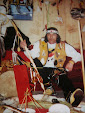
We arrived at his home and met his wife Karen, (Bennett, was the family name). She told us that he was at the fire in the bush, near his home in the backfield. We walked down a trail of memory for both Lin and me. Proceeding to the fire we were greeted by the CHIEF, Violet Bennett, in the Mi’kmaq custom along with Melvin White. I called him "Old Memento". So we gathered around the fire for a mug up, to which we were accustomed, tea steeped three times and drank black. We all had a spell to talk. Many topics arose. One was on trails and I listened. I could feel the spiritual strength around the fire, and the strength from the women. Those moments with Mi’kmaq people still exists in our society of today.
I felt kind of exiled with the whole ordeal and the moment of that day. My mind ebbed when Melvin’s dog barked , reminding me of years long ago in 1962 when I was only young boy.
Dogs were an important part of travel generations before me .I could recall my aunt Loretta and I taking the team of dogs to the Black Brook, a small stream running across what they call Steal Mt. Road,. It was seven hundred feet down Muise's Lane. My sister ,Doreen, many tines helped fetch water in this manner.
Some time you would see Math Garner and Donald Perrier pass our trail heading to the Path End and farther to the country on hunting trips. Another trail 220 feet directly West led to the Big Marsh. Old Mose Muise resided along side of the trail. That’s where Bishop Neal Ma Neal (the first Bishop of the Diocese of St.George’s), put a Mission Cross at the height of St.Georges in 1910, reasons are unknown. I think it’s to mark a battle zone, for the dead buried there. This was the oldest trail on Steal Mt. Road. It led to the cemetary and to the Catholic Church built in 1904 assisted by old Mose Muis. He had a forge and did all the steal work for the Bishop to build the church. The Bishop had his own sawmill and himself was a great carpente. All members volunteered their time to this historic event. The Court House was built after that. (The memories of the Mi’kmaq people remain as the Indian Band Council in1993 took over this part of St. George’s history under the Direction of Chief Victor James Muise (SAKE) .
There was a fork in the road, now called Court House Road. The trail then lead through the center of the cemetary, then cut across what is now Steal Mt. Road, down through Harview's Lane called today, and to Molly Ann's Brook),Seal Rocks, where ,mountaineers after the harp seals, settled in years gone by and then Mi’kmaq. I guess these would be the same people? There is the only fresh water creak in the area, draining to the west into the sea where before the railroad was put through a settlement was established.(Settlement meant one or two house , a total of seven to twelve people).
As departure came the sunlight fell at a 16-degree temperature that day, and an ease of silence arose as we went on our way.
The Big Marsh was a place every person knows, south of a pond called Hayse's Pond. There’s a path leading down the Dribble. Dribble Brook flowed into Flat Bay Brook approximately 2 and half kilometers from it’s mouth. Along this river there were paths leading everywhere, One leadto the Path End, I used to carry potatoes from the Path End to Steel Mt. Road. Liveries built huts up the river. VictorMuise had two, one cabin and one barn for storing hay in winter, also a cellar to keep vegetables in. My dad cleared four acres with his brother Walter before he went to war. This land was cleared, worked, and planted each spring.... tilling the soil with a pick ax and shovels, throughout summer making hay and then mending broken handles, healing muscles, sores, and blisters. The land is located up from Dribble Falls, used as a swing area for liveries from St. George’s. Joseph Muis and Jim Blanchard had cabins also up North from the present bridge, Jim stayed here in his last years of his life. I travelled here many times, picking apples along the way.
Still, in my mind I never forget the two war guns .I sold mind for tobacco. Walter, my cousin, and I found them on the North side of the Big Marsh, just south west of Melvin White's house. I guess it was some sort of battle field I would imagine .
After all, in 1858 there were warships from England and France patrolling the Bay St George area with an uncertain ownership.
I also noted from the Provincial Archives that five families, amounting to thirty-two individuals, have withdrawn from the settlement under fear of want for winter.
Also I noted from church files, that in 1862, in the woods about 12 miles from civilization, nine persons perished from hunger. A funeral service was held for these persons. They were all Indians. A brother of the father brought the news.

(Ancient Spirit of the White Wolf) Pikto'l Sa'ke'j Muise..
No comments:
Post a Comment